-11.1 C
New York
Home Blog Page 688

Maersk Pelican, now under new ownership, is renamed Timberwolf

0

Commenting on the sale, Tommy Thomassen, Chief Technical Officer at Maersk Tankers, said:

“This vessel was special to us. While the vessel is sold with the technology installed onboard, we will continue to work with relevant parties to enable the use of wind propulsion technology onboard product tankers, just as we will continue to capitalise on existing and new fuel-saving solutions to help owners optimise vessel performance and cut CO2 emissions.”

Tuomas Riski, CEO at Norsepower, added:

“The installation of Rotor Sails onboard Timberwolf (ex-Maersk Pelican) has been ground-breaking for demonstrating the power of wind propulsion. The two Rotor Sails underwent testing and data analysis and Lloyd’s Register provided independent analysis which confirmed fuel and emissions savings of 8.2% during the first year of operation. We look forward to continuing our co-operation with all involved parties.”

Curious stories of Antarctica: how and why the UK presented its research base to Ukraine

0

For almost 74 years in a row, one of Antarctica’s polar stations has been conducting continuous environmental research. The chain of climate observations has not been interrupted here since 1947. This is a remarkable scientific study that no other station can boast of. At the same time, scientists have to work in difficult conditions due to the very inconvenient location of the research base. The peculiarities of the station`s geographical position led to the process of transferring it from one country in favour of the other.  

Base’s features: it is interesting to visit, but it is difficult to work here

Today this station is called the Akademik Vernadsky station and the Ukrainian flag flies over it. It is located on Galindez Island, near the west coast of the Antarctic Peninsula. The research base has several special features that distinguish it from many other stations in Antarctica.

Cruise liners, whose routes pass through Antarctica, often call at the Vernadsky station, as it is the last station on the way to the Antarctic Circle. Besides, tourists are very attracted by the historical atmosphere that prevails here on this base. For example, the station has preserved buildings from ancient times, when people first came here and lived here under one roof with their sled dogs. The best Antarctica’s bar is also located here. It has not only old-fashioned interior but also an original type of alcohol, which is produced directly at the station.

Of course, tourist entertainment is a secondary issue, because the most important thing is scientific research. Unlike many Antarctic stations, the Vernadsky station works not only in summer, but all year round. It means that even when the summer season ends, conditions gradually deteriorate and winter comes, scientists do not interrupt their work and continue to collect and record all the necessary information about the environment.

Photo: Creating a channel near the station. Through this channel, researchers on a boat can get to the open water.

There is another feature in the Vernadsky station but it is less pleasant than the previous ones. We are talking about the location of the base. The fact is that this station can be reached only one way – by sea. The runway here is impossible to build due to the complex local terrain (i.e. sharp volcanic rocks, not enough flat space here). Also, there are a lot of problems with the sea route, because the station is not available for ships all year round, but only in summer. That is three or four months, no more. Then the sea is covered with ice and the station can be reached only on powerful icebreakers.

These difficulties with logistics have led to the change of owners of the station.

How the British were looking for their best heirs

This Antarctic station was built by the United Kingdom in 1947 and was named Faraday. That same year, the collection of climate data has started here, which is being carried out to this day, but with only one difference – the Ukrainians are doing this work. How did this happen?

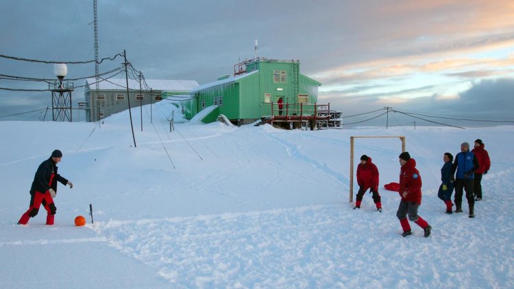
Photo: Preparing for the football championship, the final of which usually takes place at Midwinter. This holiday is celebrated at all Antarctic stations. 

The decision to transfer their polar station to another country the British made quite consciously. They started looking for a new owner in the mid-1990s. The United Kingdom had already built a new Rother science base 300 km south of Faraday. This station has a very convenient geographical location, good equipment, as well as a runway and a good berth for icebreakers. Not surprisingly, the UK eventually decided to move all of its scientists here.

Also, it was absolutely obvious that the research and observations at the Faraday station must be continued in order not to interrupt this long chain of data. So, who will do the job if British scientists have changed their location? The British Government has decided to hand over the station to “safe hands”. The search began for a country that does not have its station in Antarctica but has experienced scientists. As a result, Ukraine won this kind of tender.

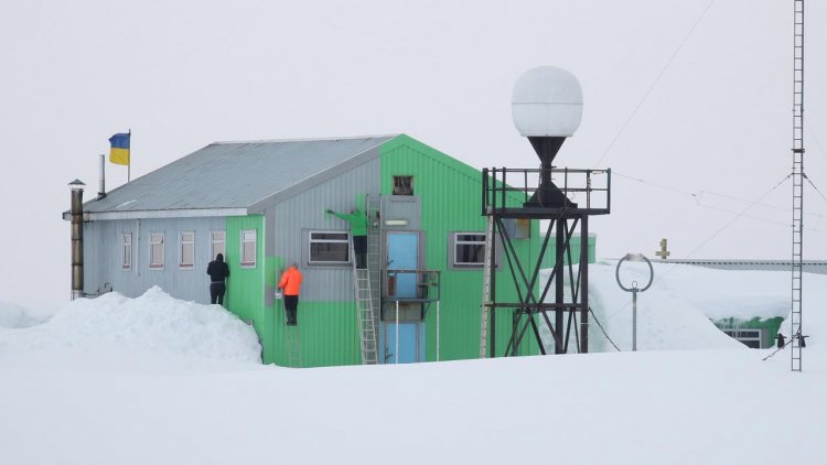
Photo: Participants of the 24th Ukrainian Antarctic Expedition (UAE) paint the facade of the station. 

Dr. Evgen Dykyi, Director of the National Antarctic Scientific Center of Ukraine (NASC), explains:

“We had several serious competitors, and, first of all, South Korea, that was ready to invest a lot of money in the project. Ukraine has won here on two important parameters. The first is the presence of its ice class fleet. In the 1990s, there were a large number of research vessels in Ukraine, some of them were of appropriate ice class.

The second advantage was our scientists, who at that time already had a great experience in Antarctica. In fact, the British could just give us the keys to the station and say: work! And we would cope with this situation. The transfer of the station really happened quite quickly – in one incomplete summer season.”

Ukraine had to regain its rights in Antarctica

Here the question immediately arises: where have the Ukrainians gained their significant experience, if their country hadn’t had its station? The fact is that the Ukrainians worked in Antarctica for many years as part of Soviet expeditions. The USSR had as many as 12 research bases there, and many Ukrainians have always worked at each of them. They were there at the time of the collapse of the Union.

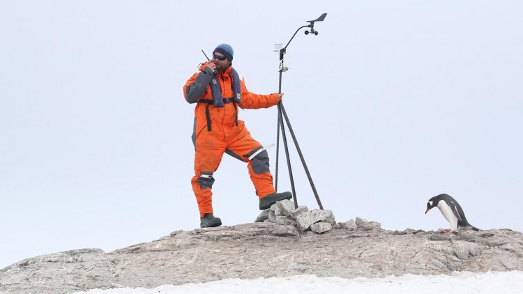
Photo: Meteorologist Alexander Zulas checks the operation of the weather station on Peterman Island.

Evgen Dykyi says:

“Then, in 1991, a miracle happened before our eyes: all 12 stations of SAE (The Soviet Antarctic Expedition, SovAE) in just one night suddenly became RAE (The Russian Antarctic Expedition). It means, Russia claimed the rights to all the USSR’s stations at once. Of course, Ukraine submitted an official diplomatic note demanding the division of bases. Moreover, we asked modestly – to leave us only one or two stations. But Russia refused to make a fair distribution. When Ukraine entered the Antarctic Treaty, already having the Faraday-Vernadsky station in its assets, Russia first blocked our accession. The Russians then insisted on Ukraine having claims to their property. We had to give an official note that we do not claim Russian stations.”

And step by step, all issues related to Faraday’s transfer from the UK to Ukraine were resolved. On February 6, 1996, the Union Jack was lowered at this Antarctic station and the Ukrainian flag was raised for the first time. So, in 2021 the station celebrates an important anniversary – 25 years since the day when the owner country changed. Then the station received a new name. It was named after the famous Ukrainian scientist, mineralogist Vladimir Vernadsky.

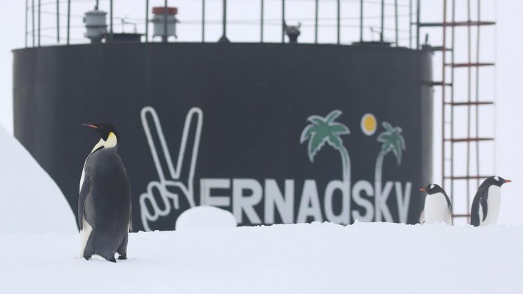
Photo: Occasionally the station is visited by emperor penguins (in the foreground), whose colonies are hundreds of kilometres away. The penguins that breed near the station are subantarctic penguins, or gentoo penguins (in the background). They have a large colony directly on Galindez Island. Due to global warming, this sub-Antarctic penguin species is moving south. Previously, these penguins haven’t formed colonies near the station.

British traditions are still alive on the Ukrainian station

It is really interesting that Ukrainian scientists are still following the same rules and traditions that were introduced by the British many decades ago.
Oksana Savenko, Research Scientist, NASC of Ukraine and Ukrainian Scientific Center of Ecology of the Sea, says:

“This rhythm of life, established by the first owners of the station, turned out to be very well thought out. Usually, everything happens like this: in the morning, each of the scientists does its job or rests after work at night. That’s why we do not have breakfast together, but lunch and dinner – this is the period when the whole station must gather together. It is important in order to understand what feelings, mood and plans the people have. We try not to miss lunch and dinner.

Usually, 11-12 scientists stay at the station for the winter, but in the summer season, there are many more people. Technicians come to carry out repair work, and the number of scientists significantly increases. That’s why we have to crowd together for a while during this period because the station is not very big in size.”

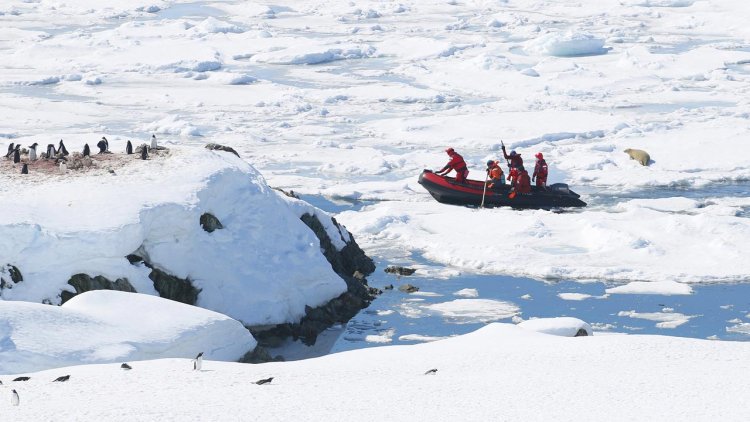
Photo: The scientists return to the station by boat after work on other islands. The icy situation near the station is unfavourable for movement.

Each expedition must include one cook and one doctor. The cook is always assisted by someone from the team, but the doctor has to rely only on his skills.
Evgen Dykyi adds:

“Of course, the station has a well-equipped surgery, but it is not possible to have a real hospital. Accordingly, during the nine winter months, while the station is blocked by ice, the doctor must deal with any situation on his own. We have  already had a critical situation when urgent medical care was needed. Then we fully felt the support and solidarity of the polar community.

In 2018, one of the expedition team members had an exacerbation of appendicitis. Our doctor tried to perform the operation in the station, but it turned out that there was a complication – peritonitis. We started looking for help, and we were very lucky. At that time there was an American icebreaker in our area and in two hours I had an answer from the Americans that they were ready to come to our station and pick up the patient. They took him 450 km to the nearest point where the plane could land. A Chilean sea transport plane was already waiting there, it took the patient to the continent. And for all their assistance, they haven’t taken a penny. Fortunately, our scientist has been cured, and he now wants to return to Antarctica again.

By the way, there were also many cases when our doctor treated tourists from cruise liners. They often call at our station and in addition to the tour sometimes have to provide medical assistance to passengers.”

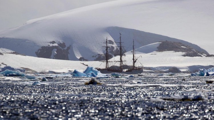
Photo: The cruise barque Europe visits the Akademik Vernadsky station every year, sometimes even several times a season.

The station has become a tourist attraction of Antarctica

In distant Antarctica, the ship’s appearance is always a big event. After all, for the whole expedition team at the station, it means meeting and communicating with new people who are not seen here for 8-9 months in a row. Oksana Savenko says:

“Tourism is a really important part of life at the Akademik Vernadsky station. Visits of tourists help to relax morally and gain new positive emotions. It is also an important mission for us – to represent Ukraine with dignity and to acquaint people from all over the world with our country. Especially since we are often visited by really famous people, scientists, sailors, travellers. We tell them many interesting stories about our research base. Journalists make documentaries about Antarctica and our scientists provide comments and talk about the station and Ukrainian research. Moreover, if small yachts with a limited number of people arrive, we invite guests to chat in the evening in our famous bar.”

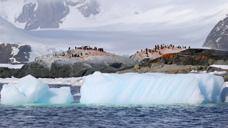
Photo: Adelie penguin colony on the Yalury Islands, near the station.

Oksana admits that some tourists find the Akademik Vernadsky station very modest, as the base is really small. But usually working in such a somewhat spartan environment causes tourists only respect and additional interest. The station already has real friends who have been visiting the Academician Vernadsky station on their yachts for 20 years. They come here absolutely purposefully.

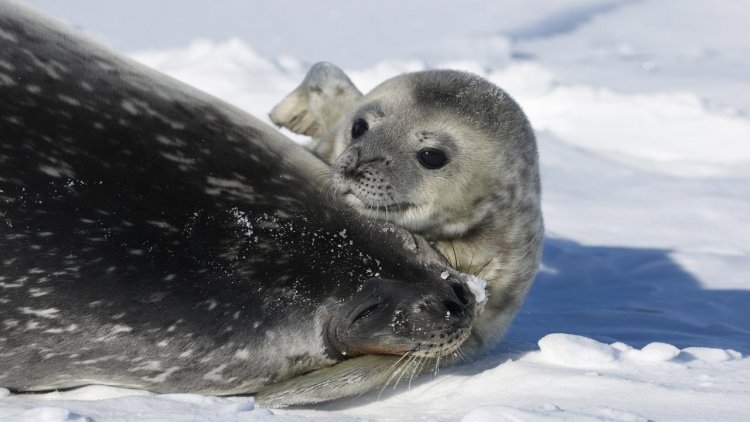
Photo: Weddell seals breed near the station every year.

Oksana Savenko adds:

“Tourists are interested here, they are constantly asking about everything. They ask about life and scientific things. Usually, guests have a good impression of the station. Once a Chinese couple came to us and photographed themselves in wedding dresses at the background of the station. This interest can be understood: when you are sailing on a large liner and around you the same picture – icebergs, whales, seals, penguins – it can be boring. And suddenly you see among the ice the aborigines who have lived here for a long time!”

Unfortunately, in 2021, cruise liners are unlikely to call at the station as often as before. The COVID-19 pandemic has left its mark on the tourism sector. Nevertheless, Ukrainian scientists continue their polar research. The 25th scientific expedition is working at the Antarctic Akademik Vernadsky station now. And the next expedition set off from Kyiv to the station on January 20, 2021. The seasonal detachment should reach Antarctica by mid-February. This means that long-term observations, which have been conducted there for more than 70 years, will continue.

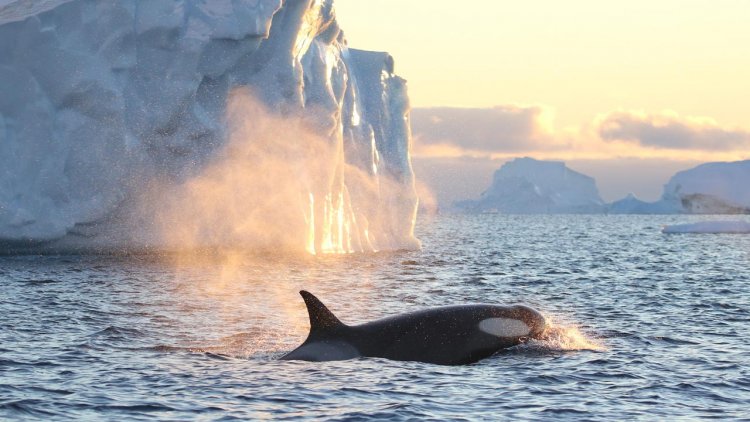
Photo: Meeting with orcas near the station almost in the middle of Antarctic winter.

by Iryna Umanets 

Maersk Drilling awarded two-well contract for low-emission rig to return to Aker BP

0

Maersk Drilling has secured an additional two-well contract for the low-emission rig Maersk Integrator with Aker BP. 

The plan is that in direct continuation of the rig’s previously announced work scope with a different operator, Maersk Integrator will return to Aker BP’s Ivar Aasen field for a two-well campaign expected to commence in Q3 2021. The contract has an estimated duration of 73 days and a contract value of approximately USD 19.5m, excluding integrated services provided and potential performance bonuses.

Maersk Integrator is contracted under the terms of the frame agreement that Maersk Drilling and Aker BP entered into in 2017 as part of the Aker BP Jack-up Alliance which also includes Halliburton. The tripartite alliance uses a shared incentives model, thereby securing mutual commitment to collaborate and drive digital initiatives to reduce waste and deliver value. Contracts under the alliance are based on market-rate terms but add the possibility of an upside for all parties, based on actual delivery and performance.

The ultra-harsh environment jack-up rig is currently completing a series of upgrades to turn it into a hybrid, low-emission rig. The upgrades are supported by a grant from the Norwegian NOx Fund and a separate compensation scheme agreed with Aker BP rewarding reductions in fuel consumption and reduced emissions.

COO Morten Kelstrup of Maersk Drilling says:

“It’s great to add another two wells which shores up Maersk Integrator’s drilling programmes for all of 2021. We look forward to continuing our close collaboration with Aker BP and Halliburton in order to add to the efficiency gains realised by our alliance. This in itself lowers the CO2 emissions associated with drilling, and the low-emission upgrades will contribute further to delivering on our target of reducing the CO2 intensity from rig operations.”

Maersk Integrator is an ultra-harsh environment CJ70 XLE jack-up rig, designed for year-round operations in the North Sea. It was delivered in 2015 and is currently operating offshore Norway.

Transport giants join forces to make Scandinavia’s largest port fossil-free

0

In an effort to speed up the transition to fossil-free fuels in the transport sector, Volvo Group, Scania, Stena Line, and the Port of Gothenburg have joined forces to bring about a significant reduction in carbon emissions linked to the largest port in the Scandinavia. 

The transport sector is a highly complex system, involving different modes of transport and organisations collectively facing big climate challenges.

Elvir Dzanic, Gothenburg Port Authority chief executive, said:

“No single organisation or individual holds the key to meeting the challenges ahead of us. Collaboration is crucial and we are pleased to bring on board two of the world’s largest truck manufacturers and the world’s largest ferry company. With our collective expertise, breadth, and market presence we can make a real difference.”

Named the “Tranzero Initiative”, this venture is focused on the one million truck transports and the 55,000 tonnes of carbon emissions generated from road transports to and from the Port of Gothenburg each year. The Initiative also includes electrification of sea transport.

The companies involved will introduce a series of interlinked measures designed to accelerate the switch to fossil-free fuels. This task has already commenced with a needs analysis and mapping of freight flows as part of the commitment to offering the market the right products and establishing a fossil-free fuel infrastructure to support this development.

Gothenburg Port Authority will produce the necessary infrastructure and access to fossil-free fuels for heavy vehicles, including electric power, HVO, biogas, and hydrogen gas. Volvo and Scania will put commercial offerings in place for their heavy truck customers, ensuring that in time land transport becomes fossil free in accordance with the goals laid down by the port. Stena Line will also have a key role to play by ensuring new fossil-free vessels are brought into service on the Gothenburg-Frederikshavn route by 2030, moving from vision to reality with its battery-powered vessel concept Stena Elektra.

The Tranzero Initiative is welcomed by the Swedish government and is entirely in line with the ambition for Sweden to become the first fossil-free country in the world. The chief executives behind the Initiative are also members of the Electrification Commission, which was set up by Minister for Infrastructure Tomas Eneroth last autumn.

The transition to fossil-free transport to and from the port will need government support for companies that need to upgrade their fleets, for example designated grants, subsidised charging points, and fossil-free fuels.

Elvir Dzanic said:

“We have had a long-standing exchange of views and ideas with the government regarding the challenges we are facing, and our goals are the same. The transport sector needs to move away from its reliance on fossil fuels and with the Tranzero Initiative we are taking a monumental step forward.”

New-generation 3D printed propeller certified by Bureau Veritas

0

With its 2.5-metre span supported by five 200-kg blades, Naval Group manufactured this new-generation propeller thanks to a metal 3D printing process.

Mounted on a Tripartite-class minehunter, the propeller will now accompany the ship on all of its operational missions.

The propeller is a technological achievement, as the largest metal 3D-printed propeller ever manufactured, and the first one made using additive manufacturing technology to equip a military ship in operation.

Obtaining military naval quality requires rigorous development. Bureau Veritas has been involved at every step of the manufacturing and testing process. 

Emmanuel Chol, Director of the Naval Group Nantes-Indret site, added:

“Including Bureau Veritas from the very beginning was vital for us to reach our goal of bringing the WAAM (Wire Arc Additive Manufacturing) process from its research & development stage to actionable industrial standards. In this regard, we are very proud to have obtained BV’s certification of the 3D-printed propeller blades, reflecting the industrial maturity of Naval Group as well as our capacity to meet the highest and most rigorous of standards.”

The first discovery this year made near the Troll field in the North Sea

0

Recoverable resources are estimated at between 7 and 11 million standard cubic metres of oil equivalent, corresponding to 44 – 69 million barrels of oil equivalent.

Nick Ashton, Equinor’s senior vice president for exploration in Norway, says:

“It is inspiring to see how creativity, perseverance and new digital tools result in discoveries that form the basis for important value creation, future activity and production in accordance with Equinor’s climate ambitions.”

The Røver North discovery adds to a number of discoveries in the Troll/Fram area in recent years. It started with Echino, which gave several answers in the autumn of 2019, and continued with Swisher in the summer of 2020.

Recoverable oil equivalent from these three discoveries can already measure against the total production from fields like Valemon, Gudrun and Gina Krog. And the exploration continues. Equinor and the partners have matured several neighbouring prospects. The Blasto and Apodida prospects in production licence 090 will be drilled after Røver Nord.

The first discovery this year was made in one of the most mature areas of the Norwegian continental shelf. After more than fifty years of exploration drilling there are still many unknown pieces in the geological jigsaw puzzle. For each exploration well that is drilled, a new piece is put into place.

Geologists, geophysicists and other subsurface personnel gain new insight and understanding which later forms the basis for new exploration opportunities. This is done in parallel with the ever-increasing use of new digital tools. In addition, the prospects drilled today face ever-stricter requirements for CO2 emissions per barrel produced.

Ashton says:

“The discovery is a direct consequence of thorough subsurface work in the Troll/Fram area over many years, and shows the importance of not giving up, but starting over, looking at old issues from new angles. Exploration thus creates great values for society, at the same time as the resources can be realised in accordance with the requirements for CO2 emissions through the value chain, from discovery to consumption.”

Exploration well 31/1-2 S and appraisal well 31/1-2 A in production licence 923 were drilled some 10 kilometres northwest of the Troll field, 18 kilometres southwest of the Fram field and 130 kilometres northwest of Bergen.

The primary exploration target for exploration well 31/1-2 S was to prove petroleum in the Brent group from the Middle Jurassic period and in the Cook formation from the Early Jurassic period. The purpose of 31/1-2 A was to delineate the discovery made in the Brent Group in well 31/1-2 S.

Both wells proved hydrocarbons in two intervals in the Brent Group. Well 31/1-2 S encountered an about 145-metre gas column in the Brent Group (Etive and Oseberg formations) and a 24-metre oil column where the oil/water contact was not encountered. A total of 50 metres of effective sandstone reservoir with good reservoir quality was found in this interval. In addition 6 metres of oil-bearing sandstone with moderate to poor reservoir quality was struck in the upper part of the Dunlin Group.

Appraisal well 31/1-2 A struck sandstones with good to moderate reservoir quality in the Etive formation and upper part of the Oseberg formation. The lower part of the Oseberg formation contained sandstone with moderate to poor reservoir quality. An estimated total of 41 metres of effective sandstone reservoir was found in the two formations. The well proved 12 metres of oil in the Etive formation, where the oil/water contact was not encountered, and a 17-metres oil column in the Oseberg formation.

The Cook formation proved to be water-filled in both wells, but with moderate to good reservoir quality. The wells were not formation tested, but extensive data acquisition and sampling took place.

The licensees consider the discovery commercial, and will explore development solutions in towards existing infrastructure.

The wells are the 1st and 2nd exploration wells in production licence 923. The licence was awarded by the Government in 2018 through the “Awards in Pre-defined Areas 2017” (APA) licensing round.

Well 31/1-2 S was drilled to a vertical depth of 3439.5 metres below sea level and a measured depth of 3555 metres. The well was terminated in the Amundsen formation from the Early Jurassic period. Well 31/1-2 A was drilled to a vertical dept of 3452 metres below sea level and a measured depth of 3876 metres. The well was terminated in the Cook formation.

The water depth at the site is 349 metres. The well has been permanently plugged and abandoned. The wells were drilled by the West Hercules drilling rig, which will now drill exploration well 31/2-22 S in production licence 090 in the northern North Sea.

First project of its kind to quantify wind farm blockage under real offshore conditions.

0

A new project to reduce the commercial uncertainty around the modelling of the Global Blockage Effect (GBE) was announced. The Global Blockage Effect in Offshore Wind (OWA GloBE) project is the latest joint industry initiative to be delivered under the Offshore Wind Accelerator and is designed to improve understanding of the true impact of the GBE by undertaking a first of a kind measurement campaign under real offshore conditions.

GBE is a phenomenon that occurs as a complex interaction between the wind farm and the atmosphere as the wind flows through, over and around large offshore wind farms. The effect is subtle, difficult to measure and hard to extract from legacy campaign data, therefore assumptions incorporated into performance calculations are impacted by existing magnitude and model uncertainties.

A number of competing classes of models and approaches to the evaluation have emerged. While there is a broad industry consensus that the GBE causes decelerations in front of offshore wind farms which reduce the energy yield, different opinions exist on how to consider its downstream impacts and how to account for redistribution of energy, for example. This is commercially relevant as uncertainty in wind turbine and wind farm performance drives a high cost of capital for offshore sites. Any over estimation of the GBE leads to the de-valuation of offshore wind projects. Consequently, efforts to increase understanding of the GBE are a key focus for the offshore wind industry.

The OWA GloBE project is led by RWE with support from the Carbon Trust as part of the Offshore Wind Accelerator programme. The project consortium currently consists of six additional wind farm developers: EDF Renewables, EnBW, Equinor, ScottishPower Renewables, Shell and Vattenfall, along with research and industry partners DTU Wind Energy and Leosphere. The project budget, including in-kind contributions, is €3.9m. Over the course of the project, leading consultancies and expert organisations dealing with GBE modelling will also be engaged to help build a broad industry consensus around the treatment of the GBE.

The OWA GloBE project centres around the planning, realisation and evaluation of a measurement campaign to be conducted in the second half of 2021, which is designed to assess the multiple aspects of the GBE at full scale and observe the atmospheric phenomena that drive it. The aim is to produce a comprehensive dataset that can be used as the industry benchmark for assessing and quantifying the impact of the GBE on energy production. 

The campaign is designed to consider and agnostically test multiple existing hypotheses on how to reflect the GBE in models and in wind energy assessments. In addition, it will test the emerging hypothesis that calculations done with rapid fully coupled methods might represent physics fundamentals associated with the GBE better than current tools. Since the rapid coupled approach combines wake and blockage models, GBE on annual energy production would be combined into an overall turbine interaction effect – removing the need to apply any further blockage treatment. Pre-investigations suggest the impact of the GBE could be less than currently assumed by the industry.

The campaign will be conducted at the Heligoland windfarm cluster in the German Bight, at the Nordsee Ost and Amrumbank West wind farms which are both wholly-owned by RWE. The two wind farms are separated by a strip of empty seascape approximately 4km wide, known as the ‘Kaskasi gap’, in which RWE will construct the Kaskasi wind farm, anticipated to go online in 2022. This provides an opportunity to create a unique experimental setup for GBE using multiple remote sensing techniques, including dual doppler scanning light detection and ranging (LiDAR) measurements in combination with turbine production data. In addition, the combination of Nordsee Ost, Amrumbank West and the ‘Kaskasi gap’ is expected to concentrate the flow features that the project aims to observe. 

Richard Sandford, Director Offshore Wind Development Europe at RWE Renewables, commented:

“The offshore wind industry will benefit immensely from the data collected in this project as it will help us gain a better understanding of Global Blockage Effect. By appraising and testing various industry hypotheses under live conditions, we will be able to close existing knowledge gaps and reach an industry-wide consensus on the effect. OWA GloBE can increase certainty in offshore wind energy yield estimates and thereby help lower the Levelized Cost of Energy.”

Jan Matthiesen, Director Offshore Wind at the Carbon Trust, commented:

“The OWA GloBE project fits well into Carbon Trust’s portfolio of joint industry activities. It has been designed with the aim of collecting an unprecedented and highly accurate dataset, which will then be analysed by world-leading research partners. The chosen test site in the ‘Kaskasi gap’ offers a unique opportunity to measure the Global Blockage Effect as it puts a magnifying glass on the phenomenon. We are confident that the project’s findings will promote industry wide consensus on global blockage at windfarm level. OWA GloBE is another good example of the benefits that can be created by collaborative R&D.”

Kongsberg Maritime to launch next-generation HUGIN Endurance AUV

0

Kongsberg Maritime is proud to announce the next generation of its advanced HUGIN Autonomous Underwater Vehicle (AUV). Named HUGIN Endurance, the new AUV boosts operational duration to approximately 15 days, enabling extended survey and inspection missions far from shore.

This longevity allows HUGIN Endurance to undertake extensive missions without the support of a mothership. Shore-to-Shore operations offer the opportunity to reduce carbon footprint for commercial activities and yet retain unrivalled data resolution and accuracy. With this in mind, KONGSBERG has added its Maritime Broadband Radio (MBR) communications system to HUGIN Endurance’s payload, allowing it to surface and share large quantities of data swiftly with any suitably equipped installation, such as another vessel, shore station or a wind turbine fitted with an MBR antenna.

For defence applications, HUGIN Endurance makes persistence a reality. Whether it is long range military survey; wide area mine detection, classification and identification; or even patrolling a choke point listening for submarines, this new extended range capability offers new solutions to existing and future challenges.

HUGIN AUVs already set the standard for autonomous underwater operations thanks to their rugged reliability and accurate, cutting-edge sensor payloads. The HUGIN Endurance is no exception; it can be equipped with a wide array of sensors including the high-resolution KONGSBERG HiSAS synthetic aperture sonar, a wide swath multibeam echosounder, sub-bottom profiler and magnetometer, together with other sensors to detect parameters such as methane, current and turbidity.

This proven portfolio of hydroacoustic sensors, communications and other technologies – teamed with unparalleled operational range – ensures that HUGIN Endurance is well equipped for advanced situational awareness scanning, and mapping/inspection activities for far-field applications such as offshore wind farms. It also delivers significant sustainability benefits, not only when contrasted with conducting operations from surface vessels but also compared with other AUV operations, as the reduction in the need for surface support further diminishes the environmental footprint.

Richard Mills, Vice President of Marine Robotics Sales, Kongsberg Maritime, says:

“We are proud to launch HUGIN Endurance, which represents a step change in AUV operations. Teaming long endurance with large area coverage capabilities allows a single AUV to map areas up to 1,100 square kilometres in a single mission – a target impossible until now. With its unprecedented long-range capability and advanced communications, HUGIN Endurance sets a new standard for autonomous subsea mapping and inspection, yielding unmatched operational flexibility, efficiency and sustainability.”

Yang Ming to take delivery of one more 11,000 TEU ship

0

Given the increased demand prior to Chinese New Year and THE Alliance’s service deployment, Yang Ming Marine Transport Corp. (Yang Ming) will take delivery of one more 11,000 TEU new chartered vessel ‘YM Target’ on February 5th.

With the support from the ship owner, YM Target can be delivered and join Yang Ming’s global fleet nearly three months ahead of schedule. The vessel will be deployed to THE Alliance’s Trans-Pacific route PN3 and provide efficient delivery service between Asia and Pacific Northwest.

To further strengthen Yang Ming’s mid- to long-term operational efficiency, the company ordered a total of fourteen 11,000 TEU newbuildings through long-term charter agreements with ship owners. YM Target is the fourth to be delivered in the series. This type of vessels has a nominal capacity of 12,690 TEU and is equipped with 1,000 plugs for reefer containers. With a length of 332.2 meters, a width of 48.2 meters, a draft of 16 meters, these vessels are designed to cruise at a speed up to 23 knots. The containerships incorporate various environmental features including scrubbers, Water Ballast Treatment Plant and Alternative Marine Power system.

In addition, these vessels adopt the twin-island design to increase loading capacity and navigational visibility to ensure more efficiency and safety. The ship hull form optimization will further increase energy saving and reduce overall emissions. Furthermore, the ships are designed with shorter length and beam, which makes them easier to maneuver during berthing or departure. The hull dimensions enable these ships to call at major ports across the world, pass through new Panama Canal with no restriction, and facilitate greater flexibility in vessel deployment.

Yang Ming started taking delivery of these new vessels in 2020. With the new ships, the company will be able to lower the average age of its global fleet and accelerate fleet optimization to achieve energy efficiency and reduce unit cost. These newbuildings will help the company to proactively cope with the challenges and stricter environmental regulations faced by the fast-changing shipping industry. Recently, the container shipping market has seen a surge in demand. During the period, the deployment of the four new vessels will enable Yang Ming to maximize capacity utilization, greatly enhance its service quality, and deliver more excellent service to global customers.

YM Target will join THE Alliance’s trans-Pacific service PN3 on February 7th, the port rotation of PN3 is Hong Kong – Yantian – Shanghai – Pusan – Vancouver – Seattle – Pusan – Kaohsiung – Hong Kong.

Blue Marine selects SERTICA Fleet Management Software for eight vessels

0

The Mexican company, already a client of SERTICA, chose the software for its reliability and consistency. Also, because it reduces operational costs through streamlined and digitalized workflows.

One of its key features, is that the user has access to a database with information about previous maintenance jobs, use of spare parts, planned maintenance projects and much more. The database also allows the user to get information about the ship and its maintenance from previous owners.

Pablo Grez, SERTICA Regional Manager in Latin America, explains:

“Taking over the SERTICA database means that Blue Marine does not need to start from scratch structuring all data, components, items and much more. They can easily adjust and continue the maintenance plans scheduled in SERTICA. The Analytics and Task List modules will without a doubt support Blue Marine in optimizing process flows and subsequent analysis.”

Joiser Ramirez Conde, Fleet Superintendent at Blue Marine agrees and adds:

“We know the software, we like it and are very confident on this new contract; our crew is familiar with the system and expect to have an easy transition.”